
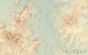
A newly documented Maya site in northern Guatemala illustrates the range of features uncovered by lidar. The elongated building at top right may have been built before 500 BCE. The large acropolis (top left) is likely a thousand years younger, though it may cover earlier constructions. [Image: Luke Auld-Thomas, PACUNAM]
Archaeologists know that the Maya people lived in a lowland region of Central America for 2,500 years, but today's thick tropical forests hide most of the details. With airborne laser mapping to peer through the foliage and intensive statistical techniques to evaluate the resulting data points, an international consortium of scientists has found the ruins of more than 60,000 buildings, as well as agricultural modifications to the landscape (Science, doi:10.1126/science.aau0137).
Pacunam Lidar Initiative
The Pacunam Lidar Initiative—scientists representing institutions in the United States, Guatemala, Slovakia and France—flew lidar surveys over 10 non-contiguous regions of northern Guatemala, totaling 2,144 km2, in 2016. The initiative follows teams that have studied other regions in Central America, although much land area still remains unmapped by lidar.
Lidar observations were collected by NCALM in July 2016 covering 2,105 square kilometers in Northern Petén, Guatemala. Coverage included the archaeological sites of Holmul, Naachtun, La Corona, El Zotz/Tikal, El Peru/Waka, Uaxactun, San Bartolo-Xultun, El Tintal, Achiotal, Witzna, and four other critical environmental study regions. [Credit: NCALM/Shrestha]
In lidar mapping, a laser emits well-timed pulses that bounce off solid objects, and a receiver collects the reflected photons. Intensive data analysis of the vertical distances between neighboring points of reflection, or “returns,” then distinguishes between the reflections from the ground and from the foliage.
Lidar mapping
The Pacunam team used a commercially available multispectral mapping lidar system that emits synchronized laser pulses at three wavelengths: 1550, 1064 and 532 nm. Some previous archaeological expeditions operated their lidar systems at the latter two wavelengths, but the newer equipment contains a third channel chosen for eye safety and spectral spacing roughly equal to the distance between the other two channels. The U.S. National Center for Airborne Laser Mapping, one of the consortium participants, started testing this instrument in October 2014.
During the archaeological survey, the system sent out roughly 15 pulses per square meter while flying about 650 m above ground level. Overall, the instrument emitted 33.5 billion laser pulses and collected roughly 60 billion returns—5.2 billion from the ground and the rest from the foliage canopy. The density of the ground points ranged from 1.1 to 5.3 points per square meter.
Rediscovering lost details
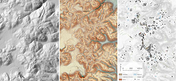
The site of Dos Torres, Guatemala. Familiar shaded relief terrain visualizations (left) can conceal subtle but important details, like low mounds or cross-channel terraces. More complex visualizations such as the Red Relief Image Map (center) make those details stand out, but even so archaeologists must identify and classify features manually for subsequent analysis (right). [Image: Luke Auld-Thomas and Marcello A. Canuto, PACUNAM]
As part of their statistical analysis of their digital terrain models, the initiative members employed a visualization technique called “prismatic openness,” which is not subject to the directional bias of conventional shading techniques on maps. This technique makes it easier for researchers to identify comparatively small structures, such as the foundations of long-abandoned residential homes.
According to the scientists, 7.7 percent of the lidar-survey area has subsequently been subjected to ground-truthing—follow-up field trips to verify that the structures and landforms identified by the lidar software actually exist. Nevertheless, the researchers estimate that the survey region contained 61,480 structures that supported a population of roughly 80 to 120 persons per square kilometer during the years 650 to 800 CE.