
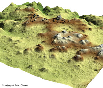
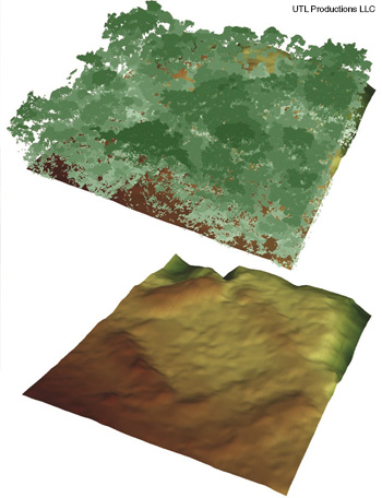
 Lidar 2.5-D image of Caracol, Brazil, epicenter.
Archaeologists, like geologists and astronomers, deal with long timescales. They study changes that happen over centuries, rather than the latest fads. Individual researchers may spend their entire careers studying a few square kilometers of earth. Their discoveries are often obscured by dense vegetation that is nearly impossible to see through.
Over the last decade, however, the advent of fast pulsed lasers and data-crunching software has given archaeologists a new tool to prospect for hidden ruins: lidar. By scanning the landscape with an airborne laser and receiver, researchers can pinpoint the locations of ancient walls, houses and roadways lurking underneath modern foliage.
Lidar excels at teasing details out of tropical jungles. Recent lidar studies in Belize, Honduras and Cambodia have revised the traditional notion that pre-industrial, pre-colonial cities in tropical regions were built like the compact, walled cities of medieval Europe, separated from the farms that fed their inhabitants. With its ability to scan large regions of territory too dense to be cleared, lidar has revealed that these civilizations, before contact with their contemporaries in Europe, created sprawling, low-density urban settlements, with agricultural terraces and broad causeways intermingled with housing and religious temples.
While traditional archaeology focuses on city centers, lidar reveals the details of farms, roadways, canals and other features that show how ordinary people lived before the jungle overtook the ruins they left behind. Archaeologists familiar with lidar surveys say that laser scanning will change their field as profoundly as the advent of radiocarbon dating in the late 1940s.
How lidar works in archaeology
Airborne lidar—the word is a blend of “light” and “radar”—operates on the same general principle as radar: A laser shoots out precisely timed light pulses from an aircraft, and a receiver on the plane collects the photons that reflect off solid objects below. The principle is exquisitely simple: The longer a photon takes to bounce back, the farther away the reflecting object is.
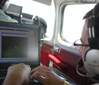 NCALM lidar engineer Juan Carlos Fernandez Diaz sends commands to a lidar system during a flight over Honduras.
Commercial lidar systems and their accompanying data-analysis software applications have advanced to the point of providing sub-meter resolution of ground features, so archaeologists don’t have to build their systems from scratch. However, according to William Carter, co-principal investigator of the U.S. National Center for Airborne Laser Mapping (NCALM), the reduction and analysis of the lidar data takes more experience than the actual data collection. What’s critical to obtaining good results is calibrating software to filter out vegetation.
NCALM began when Carter and center director Ramesh Shrestha were still at the University of Florida (the center is now jointly operated by the universities of Houston and California-Berkeley). Over Carter’s 10 years with NCALM, the laser technology has advanced from 5,000 to 125,000 pulses per second. That 25-fold increase gives the NCALM team the ability to penetrate the dense tropical forest canopy and undergrowth.
“We fly low and slow,” Carter says. He and his colleagues attach their lidar to a light aircraft flying 500 to 600 m off the ground with a forward velocity of about 60 m/s (216 km/h or 134 mph).
NCALM’s aircraft-mounted lidar unit, built by Optech Inc. of Toronto, Canada, contains two Nd:YAG lasers, one operating at 1,064 nm, a frequency that doesn’t penetrate water, and the other frequency-doubled to 532 nm, which does. For archaeological work, the plane flies back and forth in an orthogonal grid pattern, with parallel swaths that overlap each other by nearly 50 percent for good data registration. A mirror oscillating at 50 to 60 Hz spreads the near-infrared laser pulses on the ground in a sawtooth pattern.
Of course, in dense forests, lidar can’t see much bare ground. In Honduras, for instance, the treetops rise 50 m or more above the ground, and in some places shorter trees form a second canopy above the undergrowth. According to Carter, of the 3.4 billion laser shots taken in Honduras, only about 1.5 percent actually penetrated the vegetation, hit the ground and returned to the aircraft.
|
 I
IThe aerial lidar systems flown in the tropical forest environments get up to four returns per pulse—meaning that a single laser pulse can generate up to four discrete data points, depending on how jagged a surface it is measuring. For a lidar survey of the Cambodian forest, engineers from PT McElhanney Indonesia, the Jakarta branch of a Canadian surveying and engineering company, flew a near-infrared laser, set at 120,000 pulses per second, and a 40-megapixel camera attached to the skid of a helicopter. Flying 800 m above ground level, the system surveyed a swath averaging 650 m wide with every pass over the forest.
Lidar surveys generate vast amounts of data in (x,y,z) coordinates, and in raw form they look like a giant “point cloud” of signals bounced off everything below the aircraft—trees, brush, vines and the ground. In Cambodia, team members got 15 or 16 data points per square meter, whereas only 1 to 3 are needed for acceptable resolutions, says Christopher Cromarty, director of airborne operations for PT McElhanney Indonesia.
Analysts run the data through software such as TerraScan, from Terrasolid Ltd. of Helsinki, Finland, or custom filtering applications. Such applications classify the data points and filter out the points that the end user deems extraneous.
For example, Carter says, the NCALM analysts measure the vertical offset between neighboring points. Relatively “smooth” points, with little vertical offset, may indicate the ground—or an ancient road, or the top of a wall. Researchers apply different filters until they start seeing things that resemble trees, buildings and so forth. In successive iterations, they filter out the trees and underbrush and “keep” the buildings and ground surface. They can locate the structures in the lidar images because the inertial guidance system records the movements of the aircraft through a global positioning system.
The result of this processing is a digital elevation model (DEM). Analysts can apply lighting and shading techniques to the DEM to make small features more apparent to the human eye. Such shaded DEMs are often called “2.5-D”—resembling a 3-D image when viewed on a 2-D screen. The final analysis of archaeological site DEMs falls to the trained eye of a researcher with thorough knowledge of the site’s history and culture.
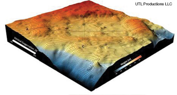
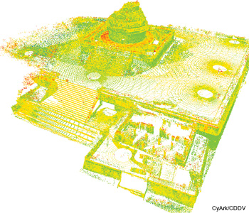 3-D point cloud of Caracol, created from laser scan data.
Caracol: Urban sprawl
For more than 30 years, Arlen F. and Diane Z. Chase, husband-and-wife archaeologists at the University of Central Florida (UCF), have explored settlements in Mesoamerica (indigenous societies of southern Mexico and Central America), mostly on foot. Early in their careers, they began focusing their efforts on the ruins of a Maya city named Caracol in southwestern Belize.
Caracol’s stone monuments, intricately carved with hieroglyphics, provide a record of the city’s rulers. The city was first mentioned in the archaeological literature in 1938, and in the early 1950s, a team from the University of Pennsylvania (the Chases’ alma mater) retrieved several carved monuments. Other than a basic site map showing where the stones had been removed, no site work had been done there in three decades. Intrigued, the Chases wanted to study how the rulers affected the city’s evolution. They took the first of what would become annual research trips to Caracol in 1985.
Soon, the Chases realized that Caracol had been a much bigger Maya settlement than they had anticipated. Ruins of causeways radiated out 3 to 3.5 km from the core of the city, leading to extended residential areas. The researchers estimated that more than 100,000 people lived in Caracol by 650 to 700 C.E., leading to the question: Where did the Maya grow enough food to feed the large population?
The Chases found traces of agricultural terraces and, in the early 1990s, received a U.S. National Science Foundation (NSF) grant to map the extent of the terraces. Over three years, however, the couple managed to chart only 2.5 km2 of farming structures because the jungle was so thick. They also surveyed about 23 km2 with traditional ground-survey instruments. Landsat satellite imagery hinted that the settlements extended at least 10 km out from the center of Caracol, but the Chases could not find the outer edges of the settlement on foot. The hilly, heavily forested terrain forced them to seek another way to determine the settlement’s boundaries.
Around the time the Chases were using their NSF grant, an archaeologist from the University of Colorado and his NASA colleague tried using single-track lidar to map a forested site. They wrote a magazine article saying that the technology was useless for the job, and that discouraged many archaeologists from trying lidar.
Many archaeologists turned to aerial photography or infrared satellite imagery to tease out patterns of ancient human habitation. However, Diane Chase says, those techniques work only in regions of relatively light tree cover and flat topography. Western Belize, with heavily forested hills, meets neither criterion.
The Chases’ search for new surveying methods led them to a UCF colleague, biologist John F. Weishampel, a tropical-rainforest ecologist who, in his previous job at NASA Goddard Space Flight Center, had used lidar to study vegetation canopies. Weishampel credits Benoit Sittler, a landscape management professor at the University of Freiburg, Germany, and Bernard Devereux, a geographer at the University of Cambridge, U.K., for pioneering the field on their home continent, where the forests are less complex and dense than in Central America.
The April 2009 survey conducted by NCALM, the Chases and Weishampel mapped 200 km2 of the Caracol region and revealed that, 1,300 years ago, it had been a large, sprawling urban center. “Ground-truthing,” or comparing the DEM generated from the lidar with the hand-drawn map of the smaller, previously surveyed region, validated the accuracy of the lidar-generated model.
 Cambodia’s Angkor region was the site of many Khmer empire capitals from the 9th through 15th centuries. The ruins are scattered in-between forests and farmland near present-day Siem Reap. Angkor’s temples were made of soft sandstone, making them susceptible to damage. A recent laser scan project gathered high-definition surveying scans and photos of the Angkor Wat Western Causeway and the temple Banteay Kdei. The data are supporting reconstruction and stabilization efforts for many Angkor monuments.
Angkor Wat and Phnom Kulen
In 2009 Weishampel traveled to India for a conference, where he met Benoit Sittler and Damian Evans, a postdoctoral fellow at the University of Sydney (Australia). The UCF ecologist recalls that they “just lit up” when they saw the detail in the results from Caracol. “We were probably just a little ahead of the curve and we just put it together right before everyone else did,” Weishampel says.
Evans, who is also founding director of the University of Sydney’s research center in the Cambodian province of Siem Reap, and his university colleague Roland Fletcher, an archaeologist, follow the Chases’ research because of their work in the Angkor region of northern Cambodia. Both the Angkor and Maya regions were settled in sprawling, low-density urban configurations.
From the 9th to the 15th centuries, Angkor was the heart of the Khmer Empire, which reigned over most of Southeast Asia. By far, the largest urban settlements in pre-industrial times arose in the Angkor region. Most tourists have heard of Angkor Wat, the huge religious temple complex built in the early 12th century, but the residents of Angkor spread out over a much larger area, the way greater Los Angeles encompasses much more than Hollywood.
“Angkor itself is a messy, confusing palimpsest of several centuries of development, and a lot of what we uncover there (especially things like reservoirs and canals and so on) are difficult to date,” Evans says. “It makes interpreting surface remains very problematic.”
Unlike Caracol, modern agriculture has overtaken a fair amount of the outlying part of Angkor, but the central section, heavily protected as a historic site, remains heavily forested. Beginning in the 1990s, French archaeologist Christophe Pottier and colleagues from the École Française d’Extrême-Orient (EFEO), the French institute devoted to the conservation of Angkor, spent eight to 12 years producing a ground-based survey of 90 forested square kilometers inside Angkor Thom. The EFEO project was “an incredible piece of work,” Fletcher says—but a lidar team could have surveyed the whole area to 12-cm resolution in an hour.
In 2012, Evans and Fletcher led an international team known as the Khmer Archaeology Lidar Consortium that surveyed 370 km2 of the Angkor region with near-infrared lidar. Participants included Jean-Baptiste Chevance of the London-based Archaeology and Development Foundation and members of the Cambodian authority that manages Angkor tourism and development. (Chevance, a French archaeologist, created the foundation to study Phnom Kulen, the relatively unexplored ruins of a 1,200-year-old settlement.)
Among other places, the lidar consortium surveyed Angkor Thom, an area that some archaeologists had identified as the capital of the Khmer Empire. Fletcher points out that Angkor Thom is simply a walled enclosure stuck into the middle of the region more than halfway through its history. In the newer, low-density model of Khmer civilization that lidar has revealed, the rulers apparently moved their administrations periodically to keep tabs on a population of roughly 750,000 people spread out over nearly 1,000 km2.
In a 2013 report published in Proceedings of the National Academy of Sciences (U.S.A.), the Angkor team found that the centers of Khmer cities were much larger than previously thought and tended to blend into the surrounding settlements—not unlike modern urban sprawl. Lidar was “absolutely crucial” in defining the extent of the settlements, Fletcher says.
Some 40 km northeast of Phnom Kulen, the lidar team surveyed Koh Ker, a heavily forested archaeological site where old landmines from the wars of the 1970s may still lurk. Koh Ker was believed to be a well-defined, single-period “ephemeral capital” of the Khmer empire, supposedly occupied for a few decades in the 10th century. “Unfortunately, it turns out that Koh Ker’s history is also much more messy and complicated than we thought,” Fletcher adds. Koh Ker’s ruins show evidence of a city center that blended into its suburban agricultural lands with well-managed water systems.
The archaeologists worked closely with the McElhanney team at all stages of the Angkor expedition, Evans says, starting with preparatory field expeditions to acquaint the lidar engineers with previous archaeological work in the region. Over the past year, the consortium’s researchers have made several treks into the field to confirm some of the features the lidar spotted and to conduct digs at residential areas near Angkor Wat. If funding comes through, the team plans to fly another lidar mission over four or five Cambodian sites, including a pre-Angkorian temple site called Sambor Prei Kuk, in 2014 or 2015.
 A lidar digital elevation model of Honduras’ Mosquitia region—the possible site of La Ciudad Blanca. Light green (top view) shows vegetation that can be removed by filtering the lidar point cloud data (bottom view).
 A lidar-based image shows a rectangular plaza surrounded by mound structures from one of the possible lost city sites.
Mexico and the “lost city” of Honduras
Besides Caracol and Angkor, archaeologists have employed lidar to study densely forested regions in Honduras and Mexico. One of the targeted sites, Angamuco in the southwestern Mexican state of Michoacán, belonged to the Purépecha people, says Christopher Fisher, one of two Colorado State University archaeologists studying lidar data from this region. Based on their Angamuco survey, Fisher and colleague Stephen Leisz plan to begin excavating this month.
Back in 2010, American documentary filmmaker Steve Elkins read about the Chases’ work in Caracol and decided to use lidar not to expand the boundaries of archaeological sites already known, but to seek out a so-called “lost city” of Mesoamerica called La Ciudad Blanca. With private funding from another filmmaker, Ben Benenson, and approval from the Honduran government, Elkins enlisted NCALM to survey part of the Mosquitia forest in the eastern region of the country.
Initial analysis of the Honduran data showed landforms that looked like pyramids and other evidence of human settlement, leading the media to hype their work as the discovery of the “lost city.” Fisher and Leisz joined the project and found additional evidence of archaeologically interesting features. When they reported their findings at a geophysics conference in May 2013, the press hyped La Ciudad Blanca all over again. The Colorado State researchers say the “lost city” is a “complete distraction” from the broader picture of pre-colonial human settlements in the region.
Researchers have yet to perform “ground-truthing” in the Mosquitia region. Elkins is raising money for more expeditions, but he cautions that the area lacks basic infrastructure such as crude roads through the extremely dense forests.
“When you’re in the jungle and you’re wandering around, you could stumble upon a giant structure and you can’t even see it from 50 feet away because it’s completely covered by dirt and plants,” Elkins says. “Lidar is like super-X-ray vision. You can ‘fly over’ and see these shapes and see if there’s anything worth walking to.”
A revolution in archaeology?
The archaeologists who have worked with lidar say that the technology is bringing about a paradigm shift in studies of Mesoamerica. Scientists will be able to survey much more land in less time, and the number of known pre-colonial archaeological sites will likely increase.
Fletcher believes that archaeologists should use lidar to survey all tropical forests—not just in Central America and Cambodia, but also in the Amazon basin and the Congo. He believes those jungle areas contain many more sites of past human settlements than scientists have been able to discover on foot.
Once scientists have completed a set of detailed DEMs for a region, Weishampel says, the data can be exploited by archaeologists, as well as foresters, climate scientists and disaster relief personnel. For instance, lidar can help measure the carbon stored in the biomass of the forests. Lidar DEMs, which constitute permanent documentation of everything on a given site at a particular time, could help find evidence of looting, illegal logging and unauthorized construction sites.
Though lidar has given archaeologists the ability to study much more space, it cannot replace the need to dig out artifacts and use radiocarbon and other dating methods to calculate how long ago humans lived in ancient areas. “You need to have excavations to fully control time,” Arlen Chase says. “Lidar doesn’t give you time. It just gives you space. Unless you have the archaeology, you cannot fully interpret it.”
Patricia Daukantas is a freelance writer specializing in optics and photonics.