
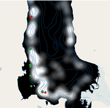
Detail map of a section of Yellowstone Lake showing fish sites identified in the lidar data from 2015 (red points) and 2016 (green points) overlaid with acoustic tracking data of lake trout (shown in black and white) from September and October 2015 and 2016. In the acoustic tracking data, black indicates low frequency of fish presence and white indicates high frequency. The lidar data show significant correlation with the acoustic data. [Image: M. Roddewig et al., Appl. Opt. 57, 4111-4116 (2018)]
Yellowstone National Park, in the United States, has been under attack from a vicious invasive species, the lake trout, for decades. But a lidar technology developed by Montana State University (MSU) researchers offers a tool for fighting back. The research team has designed and tested a device that can rapidly locate the invasive fish for removal, to a depth of at least 15 meters (Appl. Opt., doi: 10.1364/AO.57.004111).
Ecosystem onslaught
Thought to have been introduced illegally to Yellowstone Lake in the 1980s, lake trout are decimating the lake’s population of cutthroat trout, its native trout species. Cutthroat trout’s range in the states of Montana, Idaho and Wyoming has dramatically shrunk in recent decades, and Yellowstone Lake is considered a stronghold of the remaining population. Since the introduction of lake trout to Yellowstone Lake, however, the cutthroat trout population has dropped by 99 percent in some areas. Moreover, cutthroat trout are a key food source for many other park predators, including bears, otters and eagles, so this radical population collapse threatens the Yellowstone ecosystem as a whole.
To combat this ecological crisis, the U.S. National Park Service (NPS) spends approximately US$2 million every year to remove hundreds of thousands of lake trout from Yellowstone Lake. This mass culling is a time-consuming and labor-intensive process dependent on small transmitters that are surgically implanted into individual lake trout. The transmitters emit sound frequencies that park staff detect with on-boat receivers, mapping the invasive fish’s whereabouts. During spawning season, park employees locate the fish using the transmitters and use gill nets to remove them. As only around 200 lake trout are implanted with transmitters, the arduous process results in an incomplete map of the fish spawning sites.
A better way
The Montana State team wanted to develop a more effective location process that didn’t require fish surgery, so it turned to lidar. The team first tested the use of lidar technology for fish mapping in 2004, when team leader and OSA Fellow Joseph Shaw, a professor of electrical engineering at MSU, borrowed a marine-fish-detecting lidar device from the U.S. National Oceanic and Atmospheric Administration (NOAA) and conducted test flights over Yellowstone Lake—collecting data that helped NPS to locate previously unknown spawning areas.
Ten years later, in 2014 and 2015, the MSU team designed a new lidar system specifically for affordable airborne studies of freshwater ecosystems. The lidar instrument is attached to a small aircraft and works by transmitting a short pulse of laser light from the plane into the water. The lidar receiver then measures the backscattered light and allows researchers to detect fish in the water. It uses a widely available, relatively affordable 532-nm pulsed Nd:YAG laser to keep the system cost as low as possible. The laser has a 26.8-mJ pulse energy, which provides enough optical power to profile groups of two or more lake trout to a depth of up to 8 m, and a 100-Hz pulse repetition frequency, which provides continuous coverage while flying at 80 km/hour.
In 2015 and 2016, the team tested the device in flights taken over Yellowstone Lake at an altitude of 300 m at both a 5- and 15-mrad field of view (FOV), equivalent to a 1.5- or 4.5-m-diameter spot size on the water. The MSU researchers used data patterns identified in previous studies with the NOAA marine lidar to identify fish in the lidar data from their 2015-2016 experiments. According to the team, the fish locations it identified from the lidar data corresponded with the preferred characteristics of lake trout spawning sites and was consistent with acoustic tracking data from the transmitters—though further investigation is needed to determine whether the locations were indeed spawning sites.
Adopting lidar
Two main improvements of the lidar system over the transmitter approach are that it takes hours rather than days to map the lake, and researchers can detect any fish in shallow water, not just tagged fish. The MSU lidar instrument was developed for less than US$100,000 and can be flown for US$500/hour, making it a relatively inexpensive option compared with acoustic tracking devices.
The researchers believe that the system can be improved by scanning the beam along the transverse axis of the aircraft to increase the survey area, as well as improving the depth penetration of the lidar to extend the range. They conclude that airborne lidar is a promising tool for fishery managers and researchers.