
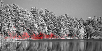
A shallow lake scene reveals excess methane emission (red) when imaged with a customized hyperspectral camera in the infrared. Credit: Magnus Gålfalk / Linköping University
Methane (CH4) is a powerful greenhouse gas that has increased 2.5 times in atmospheric concentration since 1750. The invisible gas is second only to carbon dioxide in its contribution to the greenhouse effect in the atmosphere, yet its sources are less well-understood and its accumulation rates irregular and difficult to constrain. To better grasp these issues, climate scientists in Sweden have developed a hyperspectral camera optimized for detection and mapping of CH4 at an unprecedented high spatial resolution in the infrared part of the spectrum at 7.7 µm (Nat. Climate Chg., doi: 10.1038/nclimate2877).
Magnus Gålfalk, professor of environmental change at Linköping University, and colleagues used a HyperCam Methane hyperspectral camera from Telops (Canada), customized with a narrowband cold filter to detect the strong thermal band of CH4 at 7.7 µm at a spectral resolution of 0.25 cm-1. The camera simultaneously captures a 3-D data cube for each pixel in a near-ground scene at that resolution, enabling the identification of the spectral fingerprint of methane as well as other species such as water vapor and nitrous oxide.
Unlike typical methane sensors that cover the full range of the atmospheric N band from 7.6 µm to 14.5 µm, Gålfalk’s team focused on the intermediate part of the spectrum at higher sensitivity, where CH4 lines are the strongest and water vapor is not as efficiently absorbing. This increased sensitivity enabled exposure times of 1.5 ms at a slightly lower resolution of 1 cm-1, fast enough to create movies of flowing methane.
The team was able to detect CH4 concentrations as low as 1.8 ppm, the expected ambient background value around the globe. In the future, they hope to map NO in the same spectral range.
“We plan to get the camera airborne using a helicopter and a stabilized platform,” said Gålfalk, “which would allow us to cover larger areas and obtain more sensitive measurements over water.”