
Scatterings
Using Satellite Maps to Aid Japan
In response to explosions at the Fukushima Nuclear Power Plant in the week after Japan’s 9.0-magnitude earthquake and tsunami on March 11, mapmakers at the Rochester Institute of Technology quickly made maps from satellite images to help emergency responders.
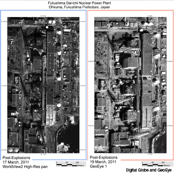 Before-and-after images of the Fukushima Dai-Ichi Nuclear Power Plant (Japan) as acquired by WorldView-2 and GeoEye-1 satellites on March 17 and 19, 2011.
In response to explosions at the Fukushima Nuclear Power Plant in the week after Japan’s 9.0-magnitude earthquake and tsunami on March 11, mapmakers at the Rochester Institute of Technology (RIT) quickly made maps from satellite images to help emergency responders.
…Log in or become a member to view the full text of this article.
This article may be available for purchase via the search at Optica Publishing Group.
Optica Members get the full text of Optics & Photonics News, plus a variety of other member benefits.