
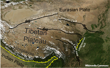
Screen capture from NASA WorldWind software of Tibetan Plateau and surrounding areas showing location of main fault zones.
Detailed maps of active fault lines can provide important information about the potential for future seismic events and can give clues about past plate movement. Unfortunately, it’s hard to map fault lines on land because vegetation can obscure ground details. A team of researchers in China and their U.S. colleague are using airborne light detection and ranging (lidar) to remove the masking effect of vegetation and other obstacles to provide precise, high-resolution 3-D images of the “bare earth” topography along the Haiyuan fault in Gansu Province, China (Chin. Sci. Bull., DOI: 10.1007/s11434-014-0199-4).
In 1920, an earthquake along the Haiyuan fault produced a 237-km-long surface rupture and killed nearly 220,000 people. It is one of the largest intracontinental earthquakes ever recorded and is therefore an important fault zone to closely monitor and study. There are two critical parameters for evaluating an active fault: measurement of displacement and geologic age. Since 1920, there have been great advances in our ability to determine geologic age. There have also been great advances in our ability to measure displacement---Global Positioning System (GPS) and now, lidar. Unlike GPS, lidar has the ability to virtually “see through” vegetation and give a clearer picture of the actual geomorphic features along an active fault line.
The lidar mapping team includes experts from China’s State Key Laboratory of Earthquake Dynamics and the National Earthquake Infrastructure Service in Beijing, and a researcher from the United States Geological Survey in Pasadena, Calif. The scanning was done with a Leica ALS-60 lidar system attached to an aircraft that made several passes over the fault area. The results of this seven-day survey included identification of an unknown fault scarp, calculation of slip rate and confirmation of coseismic offset. Hundreds of scans have been done along other areas of the Haiyuan fault. The team says their next step is to analyze the data. They hope their work will encourage others to conduct lidar scans of fault areas in other regions.